"We believe the remnants of El Nino are just about gone from the upper atmosphere. The expectation is that we'll see a building moderate to moderate plus strength La Nina Pattern (where the Inactive Phase takes control) for the remained of 2010 extending well into 2011 and likely to early 2012. In short, the next year and half is going to be tough for surfers on west facing shores in the Eastern Pacific and Eastern Atlantic, though west facing shores of the West Pacific and Atlantic might do well from the Inactive Phase's dominance "
Erzats.... is this true???
Moderator: Tex
17 posts
• Page 1 of 2 • 1, 2
Erzats.... is this true???
![]() by Gazsurf » Wed Sep 01, 2010 9:14 am
by Gazsurf » Wed Sep 01, 2010 9:14 am
regarding the forthcoming winter season of joy..................
"We believe the remnants of El Nino are just about gone from the upper atmosphere. The expectation is that we'll see a building moderate to moderate plus strength La Nina Pattern (where the Inactive Phase takes control) for the remained of 2010 extending well into 2011 and likely to early 2012. In short, the next year and half is going to be tough for surfers on west facing shores in the Eastern Pacific and Eastern Atlantic, though west facing shores of the West Pacific and Atlantic might do well from the Inactive Phase's dominance "


"We believe the remnants of El Nino are just about gone from the upper atmosphere. The expectation is that we'll see a building moderate to moderate plus strength La Nina Pattern (where the Inactive Phase takes control) for the remained of 2010 extending well into 2011 and likely to early 2012. In short, the next year and half is going to be tough for surfers on west facing shores in the Eastern Pacific and Eastern Atlantic, though west facing shores of the West Pacific and Atlantic might do well from the Inactive Phase's dominance "
"I disagree with these experts. Someone has got to stand up to experts."
Texas Board of Education member McLeroy rejecting science over creationism.
Texas Board of Education member McLeroy rejecting science over creationism.
-

Gazsurf - the kook whisperer
- Posts: 5984
- Joined: Sun Aug 28, 2005 7:22 pm
- Location: Your head
Re: Erzats.... is this true???
![]() by Spent » Wed Sep 01, 2010 10:17 am
by Spent » Wed Sep 01, 2010 10:17 am
What I want to know is, what is a La Nina Mokiki ?
Yr man from Wasabi surf seems somewhat hopeful...
http://wasabisurf.blogspot.com/2010/08/week-ahead_30.html
Yr man from Wasabi surf seems somewhat hopeful...
http://wasabisurf.blogspot.com/2010/08/week-ahead_30.html
Monday, August 30, 2010
Week Ahead
Almost Sept 1 - the official start to the Fall/Winter surfing season in Northern California. It's like Christmas for those of us who have endured a long, foggy, onshore summer. Winds are going to cooperate with the turning of the calendar month too - with light offshore flow (**mornings) forecast Wednesday and Thursday. Very small surf on tap - minimal south swell and north windswell. All eyes to the North Pacific for any hint of a significant pattern change and some swell producing storms. Watching the models for perhaps a low pressure system to get busy next weekend - but that's just hopeful thinking for the moment. We are going into a season ruled by La Nina. We may see less storm development in the West Pacific and more storms in the higher latitudes of the East Pacific as they come around blocking high pressure. This means higher angle swells (300-330), probably fewer large days like we had last season. But La Nina can mean very good surfing conditions with offshore winds for days. Colder weather, less rain (not good). We'll have to see how things unfold. In the meantime, get out and enjoy the nice weather and i'll keep you posted on any developments. cya in the water.
First Gay Marriage, then legal weed and now a goddamn skatepark in PC.
- Spent
- huntington hop wave killer
- Posts: 1399
- Joined: Fri May 18, 2007 11:36 pm
Re: Erzats.... is this true???
![]() by erzats » Wed Sep 01, 2010 2:49 pm
by erzats » Wed Sep 01, 2010 2:49 pm
Wasabi has it pretty well dialled. Whether we have la nina or el nino or neither depends on the tropical sea surface temperatures. Here's the current map:

Which is different than what we had last winter during the olympics for example:

Overall, the current SSTs are classic La Nina and are actually pointing to a quite strong event. Here's what the various models think. A lower dip is a stronger La Nina:

Our current weather pattern which is bringing some first storms to the coast is pretty right-on for a La Nina even though it's really early days. Basically, the N Pac High is strong and anomalously west allowing storms to ride down the west coast right to us. 5 days from now the forecast calls for this set up:
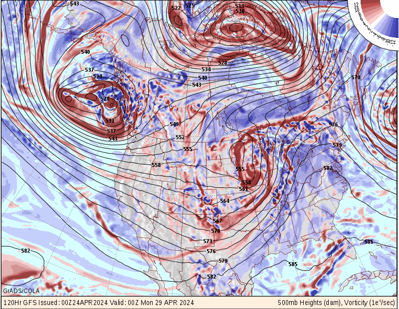
The red blobs are places where storms are or are generated, the contour lines roughly reflect storm tracks. Troughs in these lines are where storms are located. Ridges represent good weather. This type of set up is a classic snow maker were it to occur in the dead of winter. Right now, there isn't enough cold air, so no dice.
The swell chart associated with this weather looks like this:

And period:

Note the NW direction of the swell and the short period. This will be an excellent year for surf in places that need steep NW swell (I can think of a few locales where this applies). Often, La Nina conditions result in cold snaps where we are under arctic influenced high pressure. If such conditions come when a storm generates swell off of Kamchatka in the western Pacific, we get the best surf conditions of all: long period, straight west, and not too huge swell, with light offshore winds. There were a few days in late November 2009 like this.
Basically, wax up the skis/snowboards and/or move to Port Angeles, WA. But, who knows really.
Which is different than what we had last winter during the olympics for example:
Overall, the current SSTs are classic La Nina and are actually pointing to a quite strong event. Here's what the various models think. A lower dip is a stronger La Nina:
Our current weather pattern which is bringing some first storms to the coast is pretty right-on for a La Nina even though it's really early days. Basically, the N Pac High is strong and anomalously west allowing storms to ride down the west coast right to us. 5 days from now the forecast calls for this set up:
The red blobs are places where storms are or are generated, the contour lines roughly reflect storm tracks. Troughs in these lines are where storms are located. Ridges represent good weather. This type of set up is a classic snow maker were it to occur in the dead of winter. Right now, there isn't enough cold air, so no dice.
The swell chart associated with this weather looks like this:
And period:
Note the NW direction of the swell and the short period. This will be an excellent year for surf in places that need steep NW swell (I can think of a few locales where this applies). Often, La Nina conditions result in cold snaps where we are under arctic influenced high pressure. If such conditions come when a storm generates swell off of Kamchatka in the western Pacific, we get the best surf conditions of all: long period, straight west, and not too huge swell, with light offshore winds. There were a few days in late November 2009 like this.
Basically, wax up the skis/snowboards and/or move to Port Angeles, WA. But, who knows really.
- erzats
- core!
- Posts: 1175
- Joined: Mon Oct 25, 2004 11:18 am
- Location: soo wasted
Re: Erzats.... is this true???
![]() by Gazsurf » Thu Sep 02, 2010 7:24 am
by Gazsurf » Thu Sep 02, 2010 7:24 am
Gonna be occasional surf in odd places kinda year again.....
"I disagree with these experts. Someone has got to stand up to experts."
Texas Board of Education member McLeroy rejecting science over creationism.
Texas Board of Education member McLeroy rejecting science over creationism.
-
Gazsurf - the kook whisperer
- Posts: 5984
- Joined: Sun Aug 28, 2005 7:22 pm
- Location: Your head
Re: Erzats.... is this true???
![]() by erzats » Thu Sep 02, 2010 7:31 am
by erzats » Thu Sep 02, 2010 7:31 am
I think that's called surfinoregon in winter.
- erzats
- core!
- Posts: 1175
- Joined: Mon Oct 25, 2004 11:18 am
- Location: soo wasted
Re: Erzats.... is this true???
![]() by Quad Head » Thu Sep 02, 2010 12:15 pm
by Quad Head » Thu Sep 02, 2010 12:15 pm
Spent wrote:But La Nina can mean very good surfing conditions with offshore winds for days. Colder weather, less rain (not good).
Wassabi bases his forecasts on Ocean Beach San Francisco, so the above statement may not hold true for Northern Oregon? Most of the time when we're getting pummeled early winter, its sunny, offshore, and pumping down there and OBSF will definitely benefit from smaller swells this winter. The Jet Stream tends to dip later in the winter, Jan/Feb and that's when they get a good bit of moisture, and that may not happen as much in a La Nina year.
Either way just like any winter, surf wise there will be high highs and low lows. It’s Oregon. “We shall suffer” But I always get my best sessions of the year in Feb regardless. Let’s just hope during the low lows the snow is a go, cause this year when the storms hit, it was warm and the swells were to south till early spring when it finally started dumping.
Also, if history repeats itself, anyone who was here for the last La Nina winter knows shite went south in late October and stayed that way for a loooong time, at least on the Central Coast. Snow was good but I cheated and went to Baja that winter, but when I got back it blew chunks for daaaays. So get it while the gettins good and we'll see what happens when it happens.
- Quad Head
Re: Erzats.... is this true???
![]() by bluesilver » Thu Sep 02, 2010 12:48 pm
by bluesilver » Thu Sep 02, 2010 12:48 pm
ezrats doesn't use his own brains, he copy and pastes somebody elses work so it's no wonder.
When you know, you know; you know?
-

bluesilver - roach coach devotee
- Posts: 2464
- Joined: Thu May 08, 2008 12:39 pm
Re: Erzats.... is this true???
![]() by Gazsurf » Thu Sep 02, 2010 3:58 pm
by Gazsurf » Thu Sep 02, 2010 3:58 pm
bluesilver wrote:ezrats doesn't use his own brains, he copy and pastes somebody elses work so it's no wonder.
Don't get involved in a surf related thread.... you're gonna lose.
"I disagree with these experts. Someone has got to stand up to experts."
Texas Board of Education member McLeroy rejecting science over creationism.
Texas Board of Education member McLeroy rejecting science over creationism.
-
Gazsurf - the kook whisperer
- Posts: 5984
- Joined: Sun Aug 28, 2005 7:22 pm
- Location: Your head
Re: Erzats.... is this true???
![]() by ghastlysurfer » Thu Sep 02, 2010 5:00 pm
by ghastlysurfer » Thu Sep 02, 2010 5:00 pm
Gazsurf wrote:regarding the forthcoming winter season of joy..................
"We believe the remnants of El Nino are just about gone from the upper atmosphere. The expectation is that we'll see a building moderate to moderate plus strength La Nina Pattern (where the Inactive Phase takes control) for the remained of 2010 extending well into 2011 and likely to early 2012. In short, the next year and half is going to be tough for surfers on west facing shores in the Eastern Pacific and Eastern Atlantic, though west facing shores of the West Pacific and Atlantic might do well from the Inactive Phase's dominance "
Just to clarify shouldn't the last part be "though EAST facing shores of the West Pacific and Atlantic might do well from the Inactive Phase's dominance". Does this mean places like Japan in the Pacific and the East Coast of the US will get the most swell?
-
ghastlysurfer - Mermaided
- Posts: 8
- Joined: Fri Nov 16, 2007 10:51 am
- Location: underwater
Re: Erzats.... is this true???
![]() by erzats » Thu Sep 02, 2010 5:36 pm
by erzats » Thu Sep 02, 2010 5:36 pm
Fossilgrom asked for a summary, so here it is. But, I think Quad's got it dialled as does Wasabi:
The bottom line is lots of NW swell (It's up to you to decide if that's good for where you live) with generally shorter period. For the most part, swell and storms will fall right on top of each other leading to shite conditions. Many, frequent storms, so quite a bit of S-SW wind. The continental cold will deliver at least a few high pressure dominiated offshore wind periods with very cold temperatures this year. Dec, Jan, Feb, just as long as there's enough cold air in the Arctic to feed it's way to us. It'll snow like a mofo. Usually, La Nina keeps the storm track aimed right at us with a trajectory from the NW. If these lows stay west and drop south, then you wind up with a lot of classic cutoff low/santa ana conditions in Central and southern California.
I'm considering setting up a web site to track swell conditions all winter and see how it actually pans out. Memory and the data are often completely different. It would be interesting to do some stats on the wave period, direction, and size for la nina, el nino, and neutral years. Someone has probably done it, just have to check the literature.
- erzats
- core!
- Posts: 1175
- Joined: Mon Oct 25, 2004 11:18 am
- Location: soo wasted
Re: Erzats.... is this true???
![]() by grizldoldfk » Thu Sep 02, 2010 11:29 pm
by grizldoldfk » Thu Sep 02, 2010 11:29 pm
yeah, like totally dude! and you should call it something cute like "hey everybody come surf with all of us hardcores in oregon where it's always so good and we all rip.com" and then all the fukwits can roll up in their elements and subarus and check your website on their iphone with their left hand while holding their steaming lattes in their right and make sure the sun is lighting their 180 dollar recycled patagonia sweaters just right so they look like retired underwear models while they blast the coolest tunes on their satalite radios loud enough that the locals don't have to hear the sqawking of the seagulls and that annoying background swooshing sound that the ocean has been making before they all got there. that would be rad!
- grizldoldfk
- Last year's hot surfer
- Posts: 1227
- Joined: Wed Oct 06, 2004 10:29 pm
- Location: here
Re: Erzats.... is this true???
![]() by Spent » Tue Jan 18, 2011 1:13 pm
by Spent » Tue Jan 18, 2011 1:13 pm
any updates on the la nina event, erzats?
First Gay Marriage, then legal weed and now a goddamn skatepark in PC.
- Spent
- huntington hop wave killer
- Posts: 1399
- Joined: Fri May 18, 2007 11:36 pm
Re: Erzats.... is this true???
![]() by smithgrind » Tue Jan 18, 2011 11:32 pm
by smithgrind » Tue Jan 18, 2011 11:32 pm
Tudor has the answer for this dilemma.


-

smithgrind - greystoke
- Posts: 3713
- Joined: Sun May 09, 2004 9:20 pm
- Location: In Your Dreams.
Re: Erzats.... is this true???
![]() by brdsurf » Wed Jan 19, 2011 7:13 am
by brdsurf » Wed Jan 19, 2011 7:13 am
I think he is working on something a bit new and revolutionary. Looks like he has some kind of extra truck set up under his rear foot there.....
"I have to overcome that safety mechanism that wants to rise up in me and to keep me from doing something that could kill me."
"Everything’s okay until it isn’t."
"Everything’s okay until it isn’t."
-

brdsurf - straight.......like a boomerang
- Posts: 1318
- Joined: Mon Mar 08, 2004 1:52 pm
- Location: Searching for the secrets of the Gspot Massage
17 posts
• Page 1 of 2 • 1, 2
Return to Forum For People Who Think They Surf
Who is online
Users browsing this forum: No registered users and 6 guests
Powered by phpBB© 2000, 2002, 2005, 2007 phpBB Group